Skip to main content
About
Harnett County
Municipalities
Explore
Education
Departments
Board of Commissioners
Economic Development
Development Services
Emergency Services
Board of Elections
Health Department
Parks & Recreation
Social Services
Tax Department
More Departments
Government
Board of Commissioners Agenda and Meeting Packages
Board of Commissioners Minutes
Financial Documents
Planning Board Minutes, Agendas, and Staff Reports
Board of Adjustments
Development Review Board
Ordinances and Amendments
Major Subdivisions
Online Contracts
Resolutions
Search
Translate this page
SCAM ALERT: Scammers Using Email to Impersonate Staff and Solicit Payment
Planning Services
Pages
Applications
Current Projects and Applications
Long Range Planning
Meet Our Staff
North Harnett Transit Study
Online Inquiry
Planning Services Home
Zoning Map
Downloads
Applications
Administrative Review Application
Administrative Variance Application
Application for Appeal
Communications Facility Collocation Application
Communication Tower Application
Conditional Zoning
Development Review Board Application
Elevation Certificate
Minor Subdivision 3 Year Rule Exception
Pre-Development Meeting Request Form
Rezoning Application
Special Use Permit - Non-residential
Special Use Permit - Residential
Text Amendment Application
Variance Application
SNIA- Special Non-Residential Intensity Allocation
Development Guides
Buffering Regulations
Manufactured Home Parks
Recommended Street Trees
Signs
Stormwater Management Permitting
Typical Crossection
Maps
Future Land Use Map
Official Zoning Map
Zoning Adoption Map
Ordinances & Regulations
Highway Corridor Overlay District
Unified Development Ordinance
Harnett Horizons 2040 Comprehensive Plan
Hazard Mitigation Plan
Permitted Uses Chart
Firearms Discharge Ordinance
Explosives Detonation Ordinance
Noise Ordinance
Village District Design Guidelines
Plat Certifications
Exempt Plat Certifications
Minor Subdivision Plat Certifications
Major Subdivision Plat Certifications
Requirement Checklists
Exempt Plat Checklist
Minor Subdivision Checklists
Major Subdivision Checklist
Major Subdivision Site Inspection Checklist
Commercial Site Plan Submittal Checklist
Manufactured Home Park Checklist
Planning Services
Central Permitting
Inspections
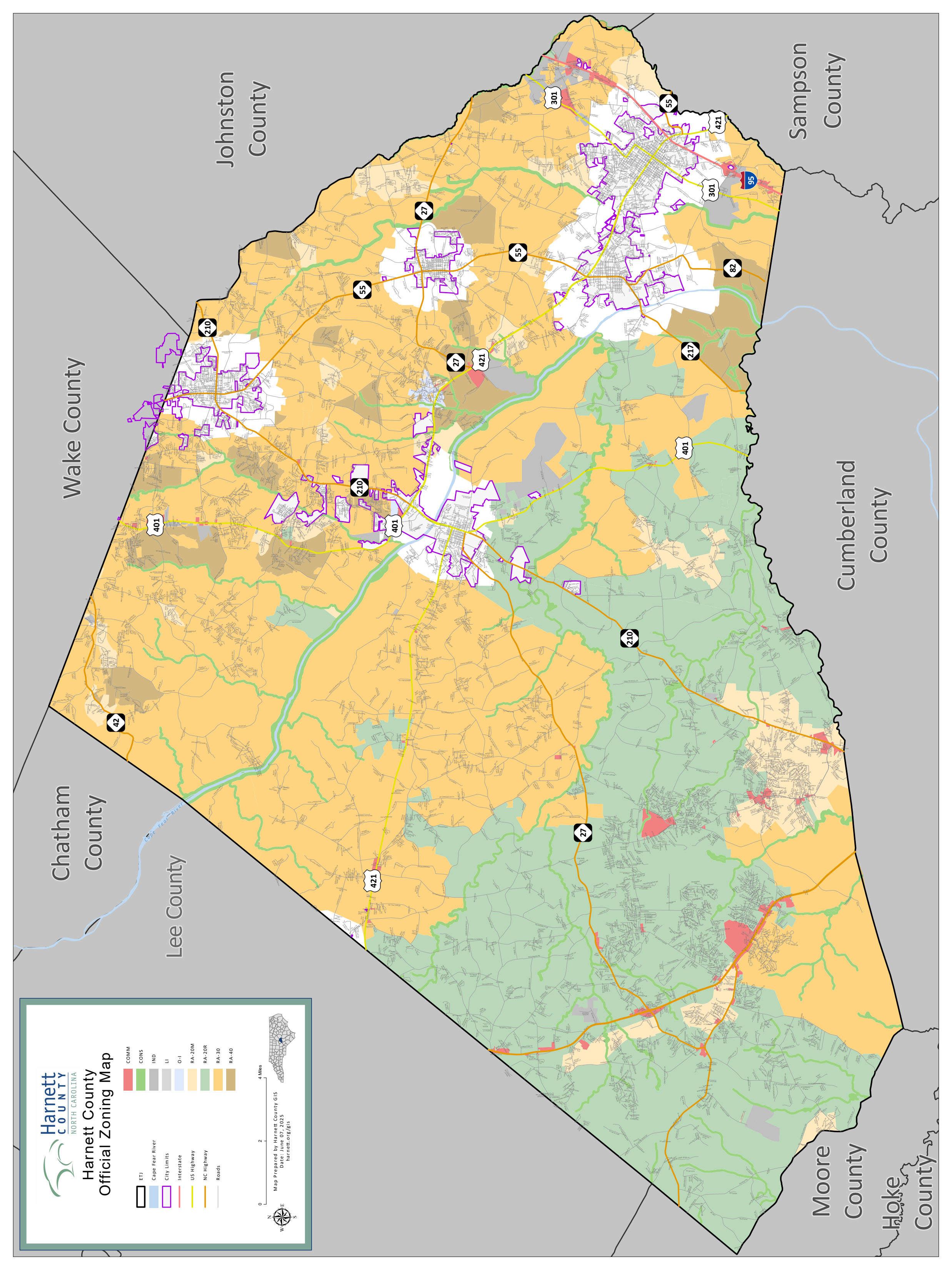
Harnett County Official Zoning Map
Download
the Official Zoning Map of Harnett County
View
the Interactive Map