Rules, Regulations, and Guidelines
ADDRESS DISPLAY GUIDELINES
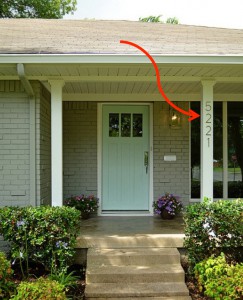
All addressable structures shall post the approved address number on the structure.
A Certificate of Occupancy shall not be issued if the address number is not properly displayed.
On a residential structure the address number shall be displayed with a minimum of 3 inch high numbers.
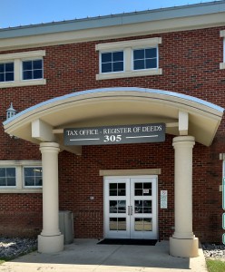
On a nonresidential structure or multifamily structure the address number shall be displayed with a minimum of 6 inch high numbers.
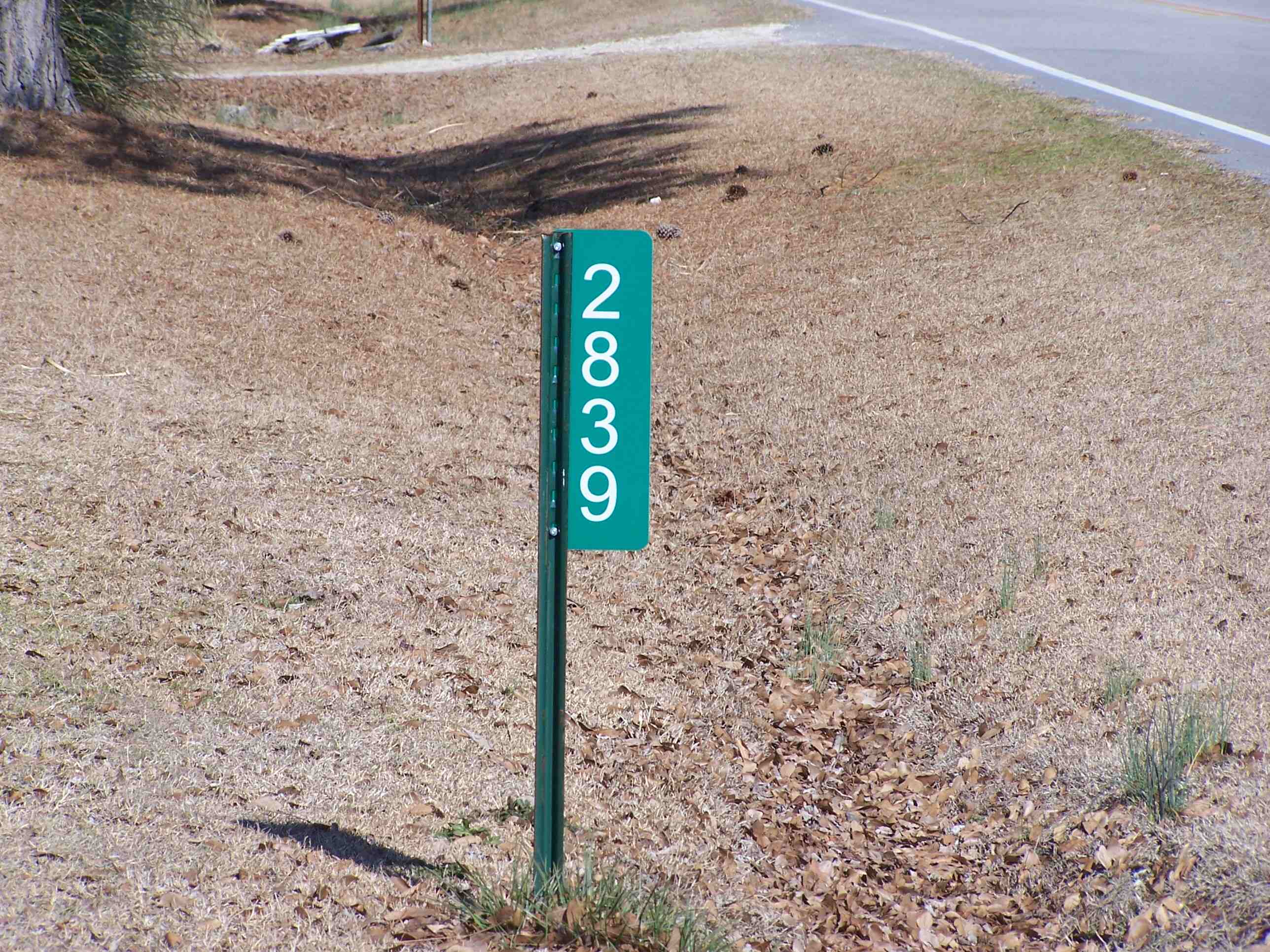
In addition to posting the address number on the structure, when the structure is not clearly visible from the road or the structure is more than 100 feet from the named road, the address number shall be display at the driveway that serves the structure. The display shall be perpendicular to the named road and shall be clearly visible from both directions both day and night.
To order a reflective address sign: CLICK HERE
For more details on how to display your address refer to the Display of Address (Article VI, Section 6.5, page 155) section of the Unified Development Ordinance.
ADDRESSING GUIDELINES
GIS/E-911 Addressing shall assign address numbers in all areas of Harnett County not within the jurisdiction of a municipality, unless otherwise requested. The municipalities of Angier, Coats, Erwin and Lillington have requested that GIS/E-911 Addressing assign all address numbers within their jurisdictions. All address numbers assigned by GIS/E-911 Addressing are recognized by the United States Postal Service as mailing addresses. All address numbers, subdivision names and road names on file with GIS/E-911 Addressing shall be official. Address numbers will be assigned every 5.28 feet from the beginning point of each road. The only exception will be existing municipal addresses the county inherited from the municipalities. Even address numbers will be assigned to right side of the road and odd address numbers will be assigned to the left side of the road, as one would stand with their back toward the beginning point of the road. All structures shall be addressed relative to their position on a named road. Structures which are facing a named road shall be addressed with the number which falls closest to the front door of that structure or unit. Structures that are more than 100 feet from a named road shall be addressed where the driveway intersects the named road. Structures not visible from the named road shall be addressed where the driveway intersects the named road. Corner lot addresses are assigned once a site plan for the structure has been submitted. One address number shall be assigned to each multifamily structure. Each unit within the structure shall be assigned a unit designator, which shall be a number and shall not include alphabetic characters.
Unit designators shall be as follows:
- Lowest floor level unit numbers shall be as follows: 101, 102, 103, etc.
- Next floor level unit numbers shall be as follows: 201, 202, 203, etc.
- Unit designators on all floor levels shall be assigned in the same manner.
For more details on addressing go to the Addressing & Naming (Article VI, Section 6, page 154) section of the Unified Development Ordinance.
MAP APPROVAL GUIDELINES
Harnett County GIS / E-911 is a Member of the Harnett County Development Review Board and the Angier Technical Review Committee.
All Major, Minor and Exempt maps are reviewed before development and then reviewed again before being submitted to the Register of Deeds for recordation.
Before development begins the road names are reviewed for each map using the following guidelines:
Map
- Any road drawn on a map shall have the approved E-911 Road Name listed on the road.
- Any state maintained road drawn on a map shall have the North Carolina Department of Transportation State Road Number listed on the road, plus the approved E-911 Road Name.
- Major highways such as US, NC and Interstates shall be listed only with the approved E-911 Road Name (example US 421 N, US 421 S, NC 27 E, NC 27 W, I-95, etc.).
- New or existing easements will be reviewed to determine if a new road name will be required. This will be determined by the number of lots, the placement of lots, existing homes and addresses located on the easement.
Vicinity Map
- Any road drawn on the vicinity map that is not state maintained shall only have the approved E-911 Road Name listed.
- Any state maintained road drawn on the vicinity map shall only have the North Carolina Department of Transportation State Road Name listed on the road.
- Major highways such as US, NC and Interstates shall be listed as US 421, US 401, etc., NC 27, NC 210, etc, and I-95.
Review Officer
In accordance with North Carolina General Statute 47-30.2, all maps with the exception of Boundary Survey and Existing Parcels shall be reviewed and signed by a Review Officer before the map is presented to the Register of Deeds for recording. The Review Officer shall verify the items listed below.
- Title of Map
- Owners Name
- Surveyors Name and Address
- Date map was drawn
- Vicinity Map
- Road names (Public or Private)
- Right of Ways
- North Arrow
- Legend
- Scale
- Control Points
- Surveyors signature, Seal (stamp) and statement - referencing GS 47-30
- Signature of the Planning Department or City/Town
- Size of map must be 18 by 24 inches or 24 by 36 inches
ROAD NAMING GUIDELINES
GIS/E-911 Addressing shall approve and maintain road names in all areas of Harnett County not within the jurisdiction of a municipality, unless otherwise requested. As part of the request to provide address numbers from the municipalities of Angier, Coats, Erwin and Lillington, the GIS/E-911 Addressing Department shall approve and maintain road names within said jurisdictions.
Road names shall be named, renamed, and/or approved in accordance with the road naming guidelines and NCGS 153A-239.1.
Any access, easement, driveway, or pathway, whether public or private, with three (3) or more addressable structures shall be named.
All named roads in Harnett County shall be identified by a sign showing the official name of that road.
To apply for a Road Name, please us THIS APPLICATION
For more detailed road naming guidelines refer to the Street Naming & Signs (Article VI, Section 6.7, page 156) section of the Unified Development Ordinance.
DEVELOPMENT GUIDELINES
GIS/E-911 Addressing shall approve and maintain development names in all areas of Harnett County not within the jurisdiction of a municipality, unless otherwise requested. As part of the request to provide address numbers from the municipalities of Angier, Coats, Erwin, and Lillington, the GIS/E-911 Addressing Department shall approve and maintain development names within said jurisdictions.
In no case shall the proposed name for development duplicate or be phonetically similar to existing developments within the jurisdiction of Harnett County. Additionally, the use of initials, acronyms, letters, numbers, and Roman numerals in development names is prohibited.
To apply for a Development Name, please use THIS APPLICATION
To review our standard message for Development Review Board and Pre-Development plat review CLICK HERE
For more detailed development naming information refer to the Subdivision Naming (Article VI, Section 6.6, page 156) section of the Unified Development Ordinance.
PIN AND PID NUMBERS
ALL tax parcels have PINs and PIDs as unique identifiers. If you receive taxes on the property you are searching for, these will almost certainly be on it. If you have the most recent deed information the parcel, you can go to the Register of Deeds search engine and enter it. If the deed was done sometime in the last couple decades, it will definitely have the PID, PIN or both.
PINs have a format of XXXX-XX-XXXX.XXX with no spaces and are very easy to search with.
PIDs are a bit more tricky as it is actually multiple sub-identifiers, based on the lot’s region, subdivision, lot etc., that form a greater number. The format of PIDs is XX|XXXX|XX|XX|XXXX|X|XX|X or Township, Map (should match first four numbers of PIN), sub-block (used in subdivisions with more than 99 lots), block, lot, undivided interest (rarely used), split numbers, and city limit split (parcels that are split between the city and the county) respectively. If one of the sections have no number, it is substituted with spaces. And almost all parcels do not use all the sections. For example, the PID for the parcel containing the Harnett County Courthouse is 110650 0008 05 or 11|0650|__|__|0008|_|05|_. The former number is what has to be entered, with the correct number of spaces (spaces after the last number do not need to be entered) to effectively search for the Courthouse by PID